Loading...
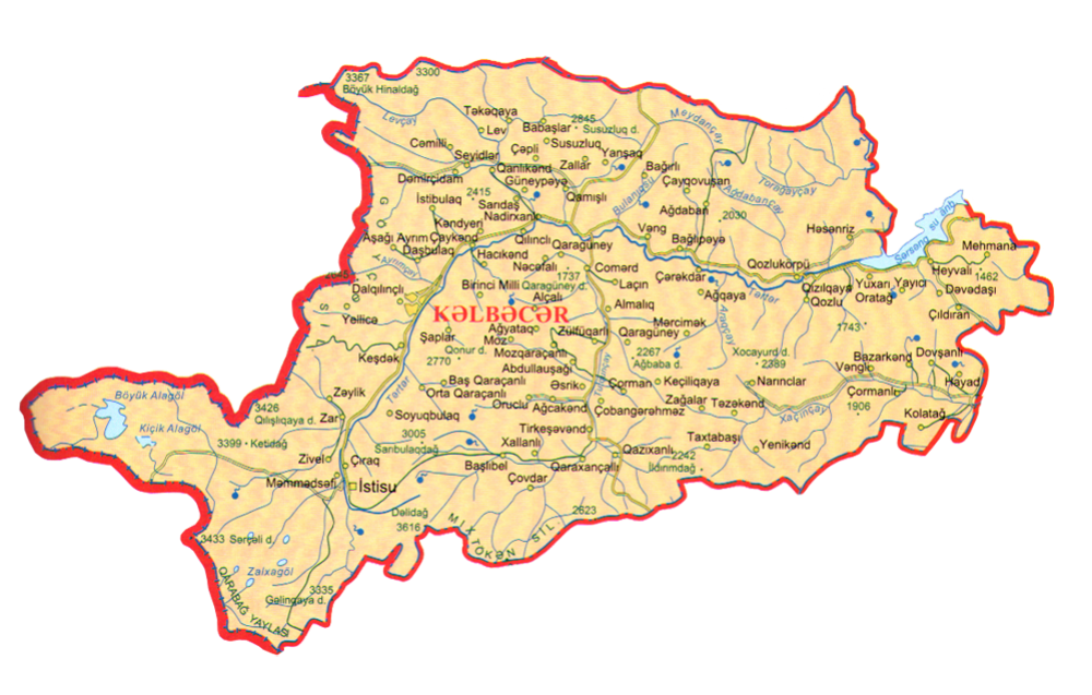
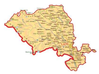
Kelbajar region borders on the Republic of Armenia in the west, Dashkesen, Khanlar (now: Goygol) regions, Terter region in the north-east, Aghdam, Khojali in the east, Lachin region in the south. The territory of the region Lachin is 3054 km2 and there was one regional centre, one urban-type settlement and 145 villages there. About 20 villages of Aghdere region were included in Lachin adminstarative division. Kelbajar granted an administrative district status on August 08, 1930.The villages are:Abdullaushaghi, Aghyatag, Fatallar, Moz, Mozgarachanli, Aghjakend, Orudglu, Tezekend, Zaghalar, Aghdaban, Baghirli, Chaygovushan, Almalig, Boyukduz, Lachin, Ashaghi Ayrim, Boyagli, Yukhari Ayrım, Baghlipeye, Veng, Bashlibel, Alirzalar, Chovdar, Khallanlıi, Shahkerem, Jomerd, Garaguney, Najafali, Piriler, Chaykend, Kendyeri, Gasimlar, Mishni, Rehimli, Chepli, Zulfugarli, Cherekdar, Childiran, Turkeshevend, Galaboyun, Garakhanchalli, Yanshagbine, Alolar, Armudlu, Bezirkhana, Hajimalilar, İlyaslar, Devedashi, Mehmana, Chirag, Mammadsefi, Tovledere, Dalghilijli, Barmagbine, Deregishlag, Otagli, Otgishlag, Dashbulag, Alchali, Allikend, Boyur, Demirchidam, Ganlikend, Bazarkend, Dovshanli, Hayad, Esrik, Chobangerehmez, Chorman, Tirkeshevend, Guneshli, Alchali, Nebiler, Hajikend, Bashkend, Heyvali, Yayiji, Hasanriz, İstibulag, Aghdash, Goydere, Keshdek, Kəremli, Kolatagh, Damghali, Gamishli, Baghirsag, Kechiligaya, Zergulu, Vengli, Zallar, Hasanlar, Zeylik, Kaha, Hopurlu, Gazikhanli, Orta Garachanli, Ashaghi Garachanli, Bash Garachanli, Kholazay, İmanbinesi, Tatlar, Gilınjlı, Alchali, Guzeychikin, Gizilgaya, Yukhari Oratagh, Chopurlu, Gozlu, Gozlukorpu, Lev, Merdgimek, Aghgaya, Birinji Milli, İkinji Milli, Uchunju Milli, Mollabayramli, Nadirkhanli, Narinjlar, Saridash, Guneypeyə, Seyidler, Jemilli, Susuzlug, Gasimbinesi, Shaplar, Mammadushaghi, Ashaghi Shurtan, Orta Shurtan, Soyugbulag, Yukhari Shurtan, Takhtabashi, Yenikend, Tekegaya, Babashlar, Bozlu, Chormanli, Garaguney, Yanshag, Yellije, Tekdam, Zar, Sheyinli, Zivel, Shahmansurlu.
The population of Kelbajar region is 94,1 thousand people (01.01.2020). 98% of the population made Azerbaijanis, the rest 2% the Russians , the Kurds from Iran and other nationalities. The etymology of the word “Kelbajer” was taken from Turkic origin that mean “fortress on the river” (the initial form was “Kevlicher”). “Kevli” means “over the river”, “cher jer” means “fortress”.
The surface is mountainous (Murovdagh, Shahdagh, East Sevan (Sevan), Vardenis, Mikhtoken, a part of the Karabakh chain and Karabakh plateau). Jamish Mountain is the highest peak (3724 m) and Dalidagh (3616 m). Jurassic, Cretaceous, Palaeogene, Neogene and anthropogenic sedimentary, volcanic-sedimentary and volcanic rocks spread in the area. The longest river of the region the River Terter, its tributaries (the Lev River, the Tutguncay River, etc.) and the source of the River Bazarchay is in the territory of Kelbejer region. In the central and northern part broad-leaved forests, forest-steppe vegetation, in the high and partly high mountains alpine and sub-alpine meadows cover a large area. The total area of the forests is 32774 hectares. Mountain goats, brown bear, wild boar, rocky place squirrel, eagles, etc.enriche its fauna.
Kalbajar is located approximately 450 km west from Baku, on the Barda –Istisu (Kelbajar) motorway, on the bank of the Tartar River, on the steep cliffs.
Kalbajar is situated at the edge of Barda-Istisu road, 450 kilometers far from Baku in the west, in the shores of Terter and on the cliffes.
There were regional department of State Security Committee of Republic Consumer-technical Agriculture, household service combinat, station of sanitary-epidemiological, 2 secondary schools, music school, cultural center, 2 mass libraries, central hospital, polylinic, cinema, maternity hospital, large trade, industrial institutions. Kalbajar is located on the mountain plain and it is in the foothills of mountains around it.
The heaven of Azerbaijan Kalbajar can be named rosary. It has more than 30 thousands springs with guests in all seasons of the year and it is museum of nature . There are more than 4 thousand kinds of plants and 200 of them are used in treatment.as a Land of rich forests Kalbajar owns hundreds of mineral springs. Istisu’s fame about curing every illness, fancy of cloudy and misty Murov, Dalidag’s many guests on its hills and its rosary of flowers are known to everyone. And so for that reason father of geology of Caucasus Avix noted about Kalbajar : “The person who has never seen Tartar valley , only then can be astonished in front of Switzerland”.
Treatment zones with mineral water fields which gave popularity to Kalbajar such as Yukhari Istisu, Ashagi Istisu, Keshdek, Garasu, Mozchay, Bagirsag, Gotorsu are under occupation.
One of the gifts that Kalbajar possesses is Istisu and the chain of hills on the west of the region. The lake Goycha is situated in the way of 300 versts with altitude of 2225 meters above sea level. It is 112 versts way to railway station. But if you go by Yevlakh-Barda railway station the way to Istisu is 200 meters from Tartar-Agdara. The way between Kalbajar-Istisu and Tartarcay is 25 kilometers. In 1940 Istisu-Tartar road was constructed.
Academic and scientist of Azerbaijan nature Mirali Gashgay said: “Istisu Mineral spring is the gift of nature. For the chemical consistence and physical features Istisu is the same with Karlovi-Vari waters (Czech Republic) and is uniqe for its some traits.
The most eminent scientist of that time Karstenski highly appreciated curing importance of those mineral waters in Istisu and he indicated that land as a place which can bring popularity to not only Azerbaijan and USSR but also to the world. The heat of Istisu waters is 58,8 0C. 1 liter of water is rich in minerals such as lithium, bromine, iodine, arsenic, phosphorus , zink, med, nickel, magnesium, iron, weighing 6,7 grams. One of the springs wells out the fountain with the height of 8 meters. According to statistics each year 3 bln 963 mln liters of water come out from Istisu springs. Water filling fabrics had used only 22 mln of this water. Istisu Mineral springs appeared as a result bulging and crack after earthquake happened in 1138. Water of Istisu is hipertermal, carbonic and there are substances such as hydrocarbon-chloride-sulphate-natrium in it. Istisu Mineral water is comprised of 12 active springs. It is situated in Kalbajar region and distinctive for its opportune gas and chemical consistence, high temperature, and natural recources. This water can be used for healing both interior and exterior ailments. 80 big resorts and Mineral water filling factory was built on the spring. That factory had been producing 800 thousand litres of water every day. Istisu sanatories #1and #2 that were very important during the former USSR functioned in the Istisu. 50 thousand people were cured and rested there each year. This spring is one of the natural resources bringing the highest amount of income to the region’s budget. Mass amount of money is spent on drilling oil. They also benefit from the assistence of foreign companies. Annual flow of Istisu is 600 mln liters. But only 10 % of this water was utilized. Turists from many countries came to seek cure in Istisu which was considered more curative than Karlovu Vari in Check Republic.
On April 2, 1993 Kalbajar was occupied by armenian aggressors. As a result of the invasion more than 54 thousand settlers were displaced, 321 were held hostages, 511 were brutally killed, 97 schools, 9 kindergardens, 116 libraries, 43 clubs, 42 cultural centers, Museum of history, 9 hospitals, 75 medical stations, 23 ambulatories, 9 chemist’s, hundreds of administrative buildings, thousands of flats, 100 thousand cattle, 500 thousand sheep, hundreds of cars and maschines were ravaged and billions of wealth of region were carried to Armenia.
As a result of occupation Kalbajar region which is Located outside of Nagorno Karabakh and is land of 58 thousand people by Armenian Military Forces, civil people were lynched and displaced from their mother lands of thousand years.
At its 3205th meeting, the UN Security Council adopted the resolution #822 after the occupation of Kalbajar. The resolution demanded immediate withdrawal of all occupying forces from Kalbajar. No obligation arising from the resolution has been fulfilled up to now.
Residents of Kalbajar are living in 707 settlements for IDPs in 56 regions of the Republic of Azerbaijan. 13.000 flats, 37,852 hectares of forests are still ravaged. Contradicting the principles of UN and OSCE settling of armenians in the area of Kalbajar had been started since 1999.
25 November 2020 - Kelbajar region was liberated from Armenian occupation. Karabakh is Azerbaijan!
Source:
Book Karabakh Memory. 2010. MHS- poligraf
Information of State Statistics Committee.