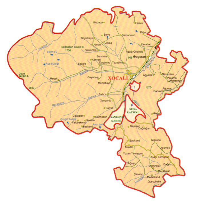


Region Khojali was established on the basis of Askeran region on 26 November, 1991. The territory of the region was occupied by Armenian armed forces in 1991-1992 years. Area of the region is 0, 94 thousand square kilometers, population is 28,8 thousand (01.01.2020) people. The distance between Khojali and Baku is 375 kilometers. The neighboring regions were: Lachin, Kalbajar, Aghdam, Khojavend, and Shusha. There was one city centre (Khojali), one settlement (Askeran), 50 villages in the region. The villages are: Almali, Garakotuk, Ballija, Xanyurdu, Mehdibeyli, Jamilli, Chanagchi, Sighnaq, Daghyurd, Dashbulaq, Badara, Xanyeri, Gayabashi, Sunjinka, Harov, Daghdaghan, Xanabad, Aghgadik, Ashaghi Gilichbagh, Kosalar, Bashkend, Janhasan, Tezebine, Gishlag, Javadlar, Yalobakend, Garabulag, Demirchiler, Gushchubaba, Madatkend, Giziloba, Ashaghi Yemishjan, Xachmach, Yukhari Yemishjan, Mesheli, Nakhchvanli, Aghbulag, Aranzemin, Dehrez, Pirjamal, Pirler, Dashbashi, Farrukh, Seyidbeyli, Ulubaba, Shushakend, Dashkend, Mukhtar, Serdarkend, Shelve.
The first category motorway with 32 km length and Baki- Khankendi railway were running through the territory of the region.Prior to the occupation there were 56 cultural enterprises, museums, colleges, secondary schools, health care facilities, agricultural and industrial enterprises, airport and so on operating in the region.
The local people mainly engaged in vine-growing, cattle-breeding, bee-keepig and farming.
The newspaper ”Khojalinin sesi (The Voice of Khojali) had been published since 1991.
As a result of the events in recent years, 54 Meskhetian-Turk refugee families displaced from Fargana (in Uzbekistan), also Azerbaijanis driven from Armenia and the city of Khankendi had settled in Khojali.
The territory of the region is mainly mountainous. The highest peaks are Gizgala and Girkhgiz (2843m, 2827 m). With the exception of mountainous areas, its climate is mild-hot. High mountainous areas are covered with subalpine and alpine meadows. The main rivers are the Badara and Gargar. Earth of it is mostly mountain-forest and mountain-grassland. 40% of the territory is rich with hazel, beech, maple, birch and other trees.
One of the unprecedented tragedies that Azerbaijan people encountered in XX century was the Khoali genocide. Like Khatun, Lidisa, Oradur genocides Khojali tragedy is the most heinous and barbarian act in the history of humankind.
Armenians attacked Khojali on February 25-26, 1992 with the help of the Russian 366th Motor Rifle Regiment. As Khojali was attacked from 3 directions, the inhabitants had to flee in the direction of Askeran. Soon it became clear that it was insidious trap. A part of town residents attempted to flee, were killed by Armenians, waiting in the ambushes near the village Nakhchivanli. Defenseless inhabitants who weakened and became dead tired on snowy passes and forests were killed by the Armenian armed with special mercilessness and inconceivable barbarism just on Askeran-Nakhchivanli plain.
During the Second Karabakh War (27 September - 9 November 9, 2020), 9 villages in Khojaly region were liberated from Armenian occupation. Azerbaijani sovereignty was established over Khojaly, and the territorial integrity of the Republic of Azerbaijan was restored. Karabakh is Azerbaijan!