Loading...
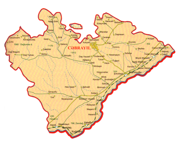
Jabrayil region is situated in the south of the Azerbaijan Republic, on the Minor Caucasus Mountains. It border on the Iran Islamic Republic in the south, Zangilan in the south-west, Gubadli in the west, Khojavend in the north, Fizuli in the east.The distance between Jabrayil and Baku is 338km.
Jabrayil granted an administrative district status on 08.08.1930. Its territory is 1.05 thousand sq.km, population 81,7 thousand people (01.01.2020).The region consisted of one adminstartive city centre (Jabrayil), 4 settlemnts, (Khalafli, Khudaferin, Gumlag, Mahmudlu) and 92 villages. The villages are: Khubyarli, Khudaverdili, İmambaghi, Gurbantepe, Shahveledli, Yarehmedli, Balyand, Khalafli, Garajalli, Yukhari Merjanli, Boyuk Marjanli, Jojug Marjanli, Chereken, Efendiler, Papı, Dagh Tumas, Chelebiler, Garaghage, Sofulu, Hagdili, Huseynalıilar, Kavdar, Mirek, Tulus, Horovlu, Chapand, Safarsha, Hovuslu, İsagli, Galagdig, Doshulu, Mahmudlu, Yukhari Maralyan, Gazanzemi, Chullu, Dagh Mashanli, Əsgerkhanli, Soyudlu, Gumlag, Derzili, Mestalibeyli, Guyjag, Nuzgar, Sheybey, Mashanli, Alikeykali, Mehdili, Chakhirli, MinbshiliAğtəpə, Dash Veyselli, Sedi, Sarijallı, Emirvarli, Mezre, Yukhari Mezre, Sirik, Ashaghi Sirik, Molla Hasanli, Khanaghabulag, Shahvelli, Goyərchin Veysalli, Haji İsagli, Goshabulag, Govshudlu, Niyazgulular, Tinli, Shukurbeyli, Dedgel, Fughanli, Hasangaydi, Shikhaliaghali, Gishlag, Karkhulu, Tatar, Ashaghi Maralyan, ikhShlar, Jafarabad, Kurdler, Dashkesen, Yukhari Nusus, Suleymanli, Niftalilar, Yanarkhage, Gushchular, Kechel Memmedli, Garar Soltanli, Ashig Melikli, Nusus.
The name of Jabrayil was taken from the name of the village Jabrayil that was the centre of the region. Father Jabrayil, who was the founder of the village Jabrayil, was one of the closes of the ruler by name Sultan Ahmed who lived in VIII century and the territories between Zuyaret Mountain and the river Araz belonged to Father Jabrayil and his sons.
The territory of Jabrayil region is rich with cement, marble, limestone and other building materials. It is also known that there are iron-ore and oil deposits there.The people in Jabrayil were mainly engaged in vine growing, grain growing, silk worm breeding and cattle breeding. Science, culture, education highly developed there. 92 doctors, 423 nurses worked in 510-beds’ hospitals. There were more than 1660 teachers working at 72 schools, 3 musical schools, 12 culture houses, 32 clubs, 10 cultural tents, autoclubs, 78 libraries, one museum and 508 cultural employees used to work in those enterprises. There were over 20 thousand exhibits in the regional History-Ethnography Musuem, 8 industrial enterprises, 42 collective farms, livestock fattening comlex, poultry farm functioned in the region.
Underground water-supply system that was formed in Azerbaijan in I century was widely used in Jabrayil. 118 underground water-supplies out of 813 in Azerbaijan are in this region. There were more than 360 ice-cold springs rich with natural minerals. Two large irrigation canals -"Teymur Guliyev" and "Maralyan" cannels- in the region provided the rapid development of agriculture. There was 4,039 ha protective forest-belt, 58.585 ha sowing area, 1079 ha garden area there.
Carpet-weaving in Jabrayil (there is also a separate carpet school in Jabrayil) was famous with pile carpets named "Gasımusaghi", "Kurd", "Garagoyunlu", "Behmenli", pileless carpets like carpet set, sackcloth (horse-cloth), holdall, saddlebag, verni, asmalig (suitable for hanging) mats, rugs, palas, farmash, kilim and gegim.
The territory of Jabrail is rich with material and cultural monuments. The cave “Divler Sarayi” locating not far from the village Dagh-Tumash, “Mesdgid Tepe”, “Jangulu”and “ Gumtepe” moundsin Galajig village, Sigeon construction on Gizilgaya mountain near the village Galajig, “Geherjik galiglar” (remainders) and “Gishlag yerleri” not far from the village Girkhlar, archeological tombs “Mazannene”, :Mermer nene” on Diridagh mountain, “Bashikesik Gumbez” in the village Daghtumash, “Gala” bridge in Sirik vilaage, “Giz Galasi” and Khudaferin bridges on Diridagh mountaian, a mosque complex in Chelebiler village, “Sultan Mejid hamami” in the city centre, “DaireviTiurbe (mauseloum)” in Shikhlar village, 8-pointed tombs and mausoleums in Turkish cemeteries are living history transferred from generation to generation. Jabrayil is the homeland of Ashug Gurban, Ashug Pery, Ashug Mughrum Kerim, Ashug Humay, Ashug Abdulla, etc. who were considered ancestors of modern ashugs.
Jabrayil was occupied on August 23, 1993 by the armed forces of Armenia. The region with 1050 square km area, 72 secondary schools, 8 hospitals, 5 mosques, 2 museums, 120 historic monuments, 149 cultural centers, about 100 villages remained in the area occupied and totally destroyed by the Armenians. During the Karabakh War 362 people became martyrs, 149 civilians became invalids, and 6 people became National Heroes of Azerbaijan.
Once 7 people from Jabrayil were awarded the title of Hero of Socialist Labor and one- Hero of the Soviet Union.
4 October 2020 - the city of Jabrayil was liberated from Armenian occupation, as were 90 villages in the region during the Second Karabakh War. Azerbaijan's sovereignty was established over Jabrayil region, and the territorial integrity of the Republic of Azerbaijan was restored. Karabakh is Azerbaijan!
Source:
Book Karabakh Memory, Baku- 2010. MHS- poligraf
Information of State Statistics Committee.